Core products Property Intelligence APIQuote-Speed and Complete profiles Underwriting WorkspaceEvidence for property decisions Portfolio IntelligenceConcentration across the book
Portfolio operations SOV IntelligenceNormalize, add property data, compare Disaster ResponseAssess properties after an event
Data services Property GeocodingAddress, parcel, building Parcel DataParcel geometry and records Change DetectionMaterial change across cycles Site & SurroundingsTrees, water, and nearby buildings

Not sure which product? See how it fits together

Data services

Property Geocoding

Resolve messy addresses against parcels and buildings, then return the match level, confidence, and reason for any uncertainty.

Parcel Data

Address → parcel → building

Match the address to the rooftop and the parcel.

Levels: rooftop, near-rooftop, parcel, and uncertain. Uncertain results include a reason.
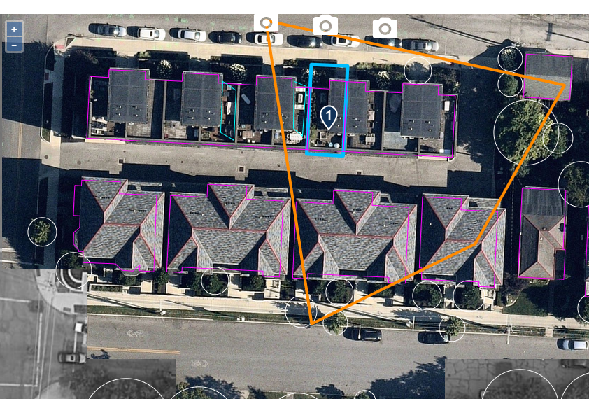
Rooftop matchOne address, one exact rowhouseThe pin resolves to the insured unit, not the block
Aerial imagery of a rowhouse block with the geocoded pin on one highlighted unit and outlines around the parcel and buildings Parcel matchedBuilding selected
RooftopPoint resolves to the selected building0.96
Near-rooftopPoint is close to a building boundary
ParcelParcel found; building match needs review
UncertainReason for uncertainty is returned
Also returned

Building footprints and parcel geometry

Return the building and parcel shapes behind the location, not only a latitude and longitude.

Data product

Parcel Data

Parcel geometry and property records for analytics and insurance workflows.

Complete profiles

Site & Surroundings

Tree proximity, nearby buildings, defensible space, coast distance, and flood context where available.

Property geocoding

Resolve each address to the building.

See rooftop, parcel, and uncertain results with reasons.

Request a demo

See GetRiskData on one of your properties or portfolios.

Tell us what you need. We reply within one business day.